On a war and a map
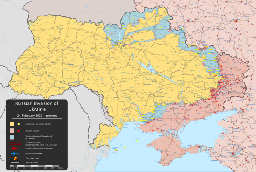
A high-quality map of the 2022 Russian invasion of Ukraine was uploaded on Wikimedia Commons the day the invasion began, and has been constantly updated since then. We interview Viewsridge, the original creator of the map, on the inspiration for the map, mapping tools, edit warring, and much more.
How did you come up with the idea to create a map of the invasion?
I first had the feeling that Ukraine was going to get invaded on 11 February 2022, after the U.S. intelligence agencies announced that Vladimir Putin had made the decision to invade Ukraine, so I requested user Rr016, a senior mapper on Wikimedia Commons, to create a map for the potential invasion of Ukraine. Rr016 created the base map on 16 February. As anticipated, the invasion began on 24 February 2022, and a high quality map was ready to go.
What tools did you use to build it?
The map is built in vector based SVG format that allows readers to zoom in infinitely without losing quality. SVG format also allows other editors to access and edit the file at ease. It was built from a blank administrative map of Ukraine by user NordNordWest, who worked from bottom up with the addition of multiple layers of rivers, roads, towns and last the frontlines showing zones of control. The curved irregular shaped lines were added with the smooth nodes function of Inkscape, a vector editor.
What's your process on working with the map?
The updates depend on the changes which take place on the ground in Ukraine. The map can be updated multiple times a day or go without an update for a day if there are no frontline changes. The Institute for the Study of War's (ISW) daily updates will also occasionally remain unchanged and this will correspond to how often the map changes.
Are there any people that you work with to update it?
Since the creation of the map, dozens of users have suggested improvements at the file's talk page. Their inputs are a great source of insight which affects the map when there is consensus at the talk page. Several editors have also worked updating the map in Commons, alongside myself.
The map is now used by news agencies around the world. What sources of information do you use to update it?
A mix of geopositioning, which is made by identifying the settlements seen in photos and videos shared by military personnel. This is further coordinated with the claims made by the belligerents about capturing or losing settlements. The ISW's maps are used to determine the claims of control by the belligerents. Maps made by the belligerents are not used, to avoid partisanship.
Thank you to Viewsridge who completed this interview in a timely fashion. If you would like to suggest any candidates for an interview, please do so on the Signpost suggestions page.


Discuss this story